
10 km NW of The Geysers, CA
· 2.1 km deep
EARTHQUAKE REPORT

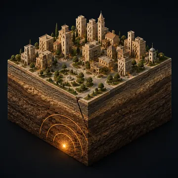
Measured depth · generated ground illustration
4.6 km below the reference surface. The marker is positioned using this event’s reported depth. The ground texture is schematic.
5 km NNW of Green Valley, CA
Loading the map…
DID YOU FEEL IT?
Not yet reported: community responses are not available in our saved report.
Select an area on the map or in the list to see what people reported.
SHAKING & DISTANCE
Each dot is one reporting area. Select a dot to find it on the map.
Distance from the earthquake source includes depth. The distance scale is logarithmic; the intensity scale is linear.
AS THE REPORTS ARRIVED
The timeline counts responses received. The map shows the latest geographic summaries; USGS does not publish individual response locations linked to these times.
EXPLORE THE AREAS
These are public USGS geographic aggregates, not individual questionnaires. Community intensity describes the combined responses for an area; it does not measure shaking at every building. Small groups and USGS-flagged areas deserve extra care. ShakeMap estimates and community reports are separate products.
How USGS turns responses into community intensityReports within roughly 3° of latitude and longitude and 7 days of this event. Proximity does not establish an aftershock relationship.
· 2.1 km deep
· -0.2 km deep
· 1.6 km deep
· 1.8 km deep
· 1.5 km deep
· -0.1 km deep
MAKE SENSE OF THIS REPORT
Explore an illustrated Earth cutaway, compare earthquake energy and discover the separate felt-intensity scale in our interactive 3D lab.
Explore magnitude & shakingKeep exploring with the astronomy calendar, local weather alerts and the earthquake field guide.
This page does not carry live tsunami warning status.
Check official tsunami messagesDrop, cover and hold on. Follow local emergency instructions.
USGS earthquake safety guidanceThis page preserves the last USGS information collected by Forecast Bar. Magnitude, depth, location and felt reports may be revised.
The daily feed is normally checked every two minutes. A separate background check collects older revisions and withdrawals every ten minutes, with catch-up time after interruptions. Use USGS for the latest source information.